Semeru Volcano


Semeru volcano is situated in the Bromo Tengger Semeru National Park in south-east Java. It forms the S end of a volcanic massif extending N to the Tengger caldera, via mt. Kepolo, Ajek-Ajek and Jambangan. The Bromo cone in the Tengger Caldera is the only other active volcano in the massif in historical times. With a summit altitude of 3676m, Semeru is currently the highest volcano on Java. The base of Semeru is made up the older edifice of Mahameru, on top of which the younger Seloko edifice with the currently active Jonggring-Seloko vent has been emplaced. The Seloko edifice has a volume of about 60km3 and is made up of layers of andesitic deposits. The active vent sits at the top of a SE trending scar in the edifice, which channels rockfalls and pyroclastic flows during phases of heightened activity. The partially exposed walls of several older craters in the summit area suggest that activity has migrated from NW to SE.

Most scientific studies on Semeru have focussed on the secondary hazards presented by lahars to the nearly a million people living in the 1800 km2 ring-plane which extends from the base of the mountain to the coastline to its S and SE. Lahars occur when loose volcanic material is remobilized from the flanks of the volcano by heavy rainfall. Further, debris flows resulting from partial collapse of the flank during heavy rainfall may present a hazard to downstream settlements. Since Lahars and Debris Flows are not direct results of activity, these are addressed seperately at the bottom of the text.

Semeru has been in almost continuous eruption since 1967. The eruptions are predominantly strombolian / weak vulcanian in nature, although periods of heightened activity involving larger explosive events, block lava flows and pyroclastic flows occur. Access to the summit region is usually permitted, yet ballistics may reach the crater rim and have caused injuries or fatalities in the past.


Tengger Caldera Bromo Semeru Nighttime Eruption Semeru Volcano

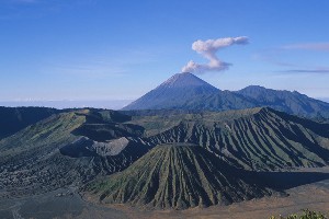
Ash cloud from Semeru. View over Tengger Caldera with Bromo crater towards bottom left of picture.

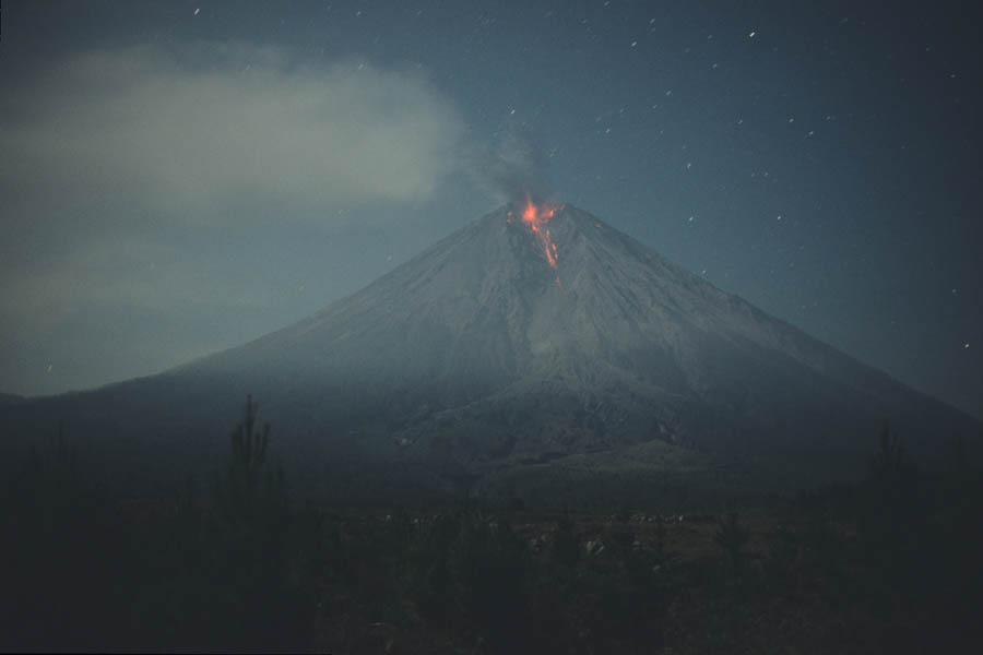
Nighttime view of summit eruption of Semeru Volcano.


Scientific reports of activity at Semeru date back to 1884 and are summarized in Thouret et al., 2007 (Bull. Volcanol. 70, p.221-244). Activity reports from 1972 onwards can be found in bulletins of the Smithsonian GVP. Semeru was frequently active in the 20th century. Several forms of activity can be distinguished. According to Thouret et al., 2007, there are three different regimes.

The regular explosive regime involves (i) frequent, several hundred meter high, white-grey phreatic eruption columns lacking juvenile material, (ii) vulcanian explosions producing ash-rich columns rising up to 3km above the crater, carrying with them incandescent blocks, and (iii) phreatomagmatic explosions expelling ash and small volumes of non-juvenile material and bread-crust bombs. This regime is generally accompanied by low-level extrusion of lava from the dome-plug. Incandescent rockfalls sporadically result from crumbling of the flow-front. The activity is influenced by seepage of rainwater from the host-rock into the vent.

The second regime involves increased extrusion resulting in formation of a small dome, collapses of which may result in pyroclastic flows down the SE scar and onto the ring-plain beyond. Further, more powerful explosions creating 3-7km high ash-rich columns and projecting ballistics up to 3km from the crater are observed.

A third regime was defined as the eruption of lava flows from up to 1km fissures on the flank of the cone. Such flows were observed on the ESE flank in 1895 and 1941-42. Many further older flows can be seen on the lower SW, SE and E flanks.

Whilst Thouret avoids the terminology strombolian to describe the minor explosive activity, Siswowidjoyo et al., 1997 (J. Asian Earth Sci. 15(2-3), p.185-194) describes the regular regime as largely strombolian in character, with vulcanian explosions only occurring during phases of heightened activity. The regular explosive activity has been studied and compared with explosive activity at Japanese volcanoes Sakurajima and Suwanosejima by Iguchi et al., 2007 (J. Volc. Geotherm. Res. 178, p.1-9). Iguchi noted that the ground surrounding the active vent of Semeru gently inflated starting from 3-30 minutes pre-eruption. Just before the eruption, a short period of deflation (2 secs) starting 6 sec pre-eruption could be detected and correlated to observation of degassing (visible steam emission) from vent. After the brief deflation, several seconds of rapid inflation preceed the eruption, after which rapid deflation occurs as gas and ash are expelled. The source of the inflation was suggested to lie only 100m deep at Semeru and involved a volume change of 100-500m3. Iguchi explains the eruption mechanism as follows. A gas pocket exists at the top of the conduit exerting outward pressure on its walls. As the pressure rises the edifice inflates gradually. Once the pressure reaches a critical level, some of it escapes through the cap plugging the vent. This causes brief deflation. The reduced pressure at the top of the conduit however triggers rapid degassing of deeper water-saturated magma causing a rapid rise in pressure (and consequently inflation), eventually, seconds later, resulting in explosive destruction of cap at the top of the conduit. This results in significant pressure release and thus deflation of the edifice. The cycle then recommenses. Based on this theory, short-term fluctuations in time between explosive eruptions should be largely determined by porosity and strength of the cap and any pressure retained after previous eruption.


Sketch Map Semeru Volcano

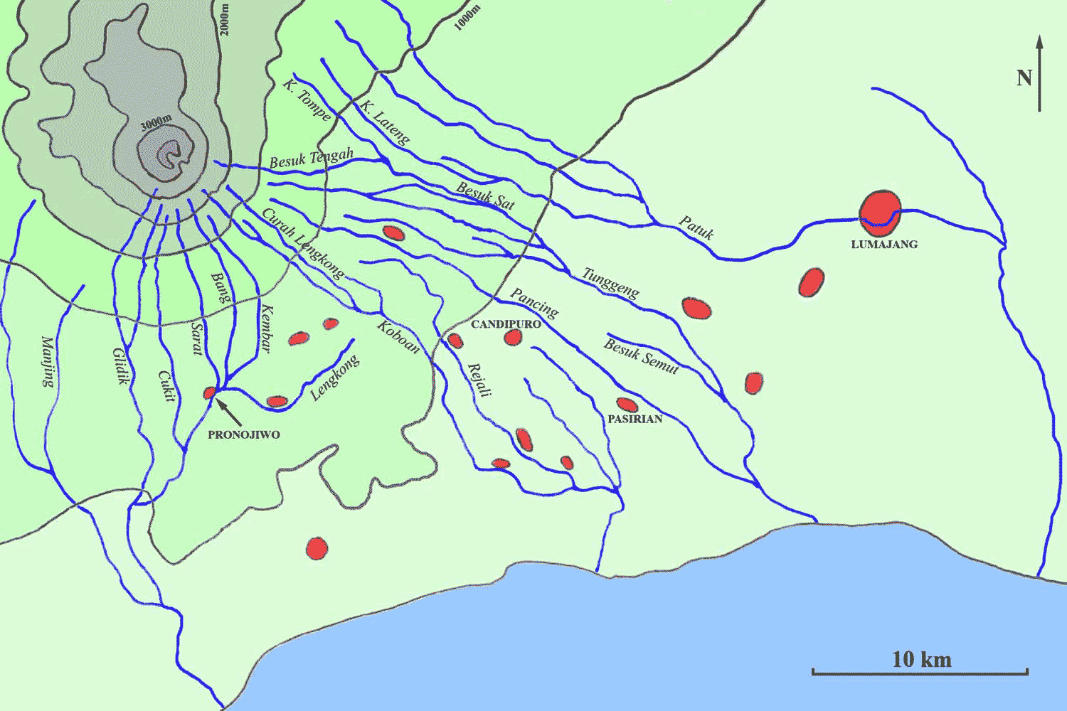
Sketch Map of Semeru Volcano and Areas on the ring-plane affected by Lahars and Pyroclastic Flows. Click for larger version in seperate window.


The current eruptive phase, which started in 1967 commenced at the site of the previous 1963 eruption. The activity has been much as described above and involved the formation of a small lava dome and slow extrusion of block lava flows of up to 2km in length. Minor pyroclastic flow activity resulting from collapses of the block flow front were observed. A first fatality was reported in 1981, when pyroclastic flows reached a length of up to 7km during a period of heightened activity. In March 1990, it appears that the lava dome was destroyed. The actual event is poorly documented apart from accounts of increased ashfall nearby, yet observations in July revealed a large pit at the former site of the dome. No significant-sized dome has been emplaced in the active Jonggring Seloko crater since then. The type of activity after loss of the dome otherwise remained similar to that beforehand. On February 3rd 1994, increasing activity culminated in a powerful eruption triggering pyroclastic flows which extended up to 11.5km SE of the summit down the Kembar and Koboan rivers. 6 Fatalities were reported in Sumbersari village. This raised awareness with the authorities, so when pyroclastic flows reached a length of 9.5km on 20 July 1995, a warning issued shortly beforehand prevented any casualties. Fatalities have also occurred due to impact of ballistics near the active crater. The pyroclastic flows were all initially channeled down the SE scar, suggesting that the primary source was the lava lobe which may have been disrupted by the explosion and accompanying seismic activity, rather than a large collapsing eruption column.

In September 1997 two german climbers were killed, then on 27 July 2000 a group of volcanologists were surprised by an unusually violent explosion and two of them unfortunately lost their lives, with several others being injured. The most recent notable activity was reported in december 2002, when pyroclastic flows travelled up to 9km from the summit. Eruptions continue at present with slight dome-building and pyroclastic flow activity (up to 2-3km long) being reported in May 2008. This is not entirely unexpected, since Semeru appears to go through phases of increased activity about every 5-7 years.

Much recent research on Semeru focusses on assessment of Hazards to the local population, in particular the risk of lahars or debris flows (like lahars but more concentrated with over 60% sediment volume). The Thouret et al., 2007 paper provides an extensive analysis of past events, mitigation measures and current hazards and provides much of the basis for the following text section.

First historical reports of fatalities due to lahars at Semeru were related to the 1884-1885 eruptive period. In April 1885, a partial collapse of the crater rim and lava tongue (total volume 26 million m6) occurred followed by a powerful explosion. A large lahar occurred more or less directly after the event and swept mainly down the Koboan (also called Kopokan) drainage, inundating 2 villages and claiming 70 victims. A similar amount of victims was again claimed in 1895 when lahars inundated several drainages incl. Besuk Sat and Tunggeng during a period of heightened eruptive activity. On 22. March 1909, during heavy rainfall, a huge landslide triggered a massive debris flow which first entered the Besuk Sat and Tunggeng drainages before overflowing amongst other places into the Lateng drainage which carried it into the city of Lumajang, 35km E of the volcano. A total of 38 settlements were inundated in an area covering 110km2, 1450 houses were destroyed in Lumajang, and a total of at least 220 people perished along with lots of livestock. Following this event, the dutch colonial authorities started to implace protective structures in the area. Forty-five 3m high artificial "escape hills" (vluchtheuvels) were built near the Pasirian and Candipuro settlements and a dam was built to prevent overflow into the Lateng drainage. In 1956 a small debris flow again occurred and flooded parts of Lumajang. 220 victims were claimed by the flow as it descended several drainages (Note: Siswowidjoyo attributes no fatalities to this flow). In 1976, lahars swept down several drainages (Glidik, Lenggong, Rejali, Liprak, Koboan, Kembar, Bang) and claimed 133 victims, largely because the flow changed direction unexpectedly. 1978 again claimed 12 victims due to widespread lahars.

On 14 May 1981, during a period of heightened activity, over 30cm of rain in 3 hours preceeded in a landslide on the E flank with an estimated volume of over 5 million tonnes (6 million m3). The landslide occurred at a similar site to the 1909 event, between 1600 and 2000m elevation, and poured into the same drainages (Tunggeng and B. Sat), however the city of Lumajang was spared due to protective dykes and dams, even though one dyke built in 1912 was swept away by the flow. Nevertheless, the flow resulted in over 275 fatalities, possibly largely because the event occurred at night. Apparently nobody reached the protective escape hills. The 1981 event again triggered the construction of protective structures and further research into hazard mapping in the area. It is currently considered that at least 350km2 of river valleys and low-lying areas on the ringplane are at risk from lahars near Semeru.

Whilst the two most deadly events were the result of landslides on the E flank (the recurrence of which is a major concern, as is possible failure of the deeply eroded and steep-sided summit cone), most events (many of which were omitted above as they only involved damage to farmland or infrastructure) were the result of remobilization of recent volcanic deposits by heavy rainfall. Semeru is unvegetated above an altitude of 2000m and loose materials are readily washed down the flanks. Along with Sakurajima and Merapi, Semeru is one of the most prolific sediment-producing volcanoes on the planet. Whilst high-magnitude eruptions such as that of Pinatubo in 1991 result in far larger amounts of sediments in drainages, levels rapidly fall in the years after the eruption. In contrast, annual sediment yield from Semeru only fluctuates slightly in response to changes in activity and remains high due to ongoing emplacement of pyroclastics in the vicinity of the active crater. Whilst annual fluctuations are small, seasonal fluctuations are significant and directly correlate to levels of rainfall at different times in the year. Most flows occur in the rainy season between November and April, usually in the afternoon when monsoonal convective rainstorms are most intense. Lavigne and Suwa (Geomorphology 61, p.41-58, 2004) studied the trigger mechanism for different types of lahars at Semeru. Debris flows with over 60% sediment concentration, hyperconcentrated flows (20-60%), and stream flows (under 20%) were observed along the Lengkong drainage and correlated to patterns of rainfall. Lavigne and Suwa concluded that 90% of debris flows were triggered by intense stationary rainfall on the upper slopes. On the other hand, over 60% of hyperconcentrated and stream flows were triggered by migratory rains driven NW up the flank. These rains are less intense but may last longer and are less seasonal. Lahars also may occur following light rain if the ground was previously saturated. This is an important observation regarding prediction of lahars. The volume of material transported by a single lahar may be immense. Lavigne and Suwa recorded maximum flow volumes of up to 67 to 245 m3/sec at flow speeds of up to 6m/sec in 21 debris flows studied. The average volume was from 105 to 106 cubic meters with mean durations under 90 minutes. It should be noted that these were regular events which caused little or no destruction.


Photovolcanica Full Index