Kilauea Volcano


Kilauea is located on the SE flank of Mauna Loa, on Big Island, Hawaii. However, Kilauea has its own magma system, distinct from that of Mauna Loa, and it thus a volcano of its own right. Kilauea, like Mauna Loa, is a shallow-sloped shield volcano. Eruptions of Kilauea occur at either the summit caldera, or along the rift zones. These mark areas in which parts of the volcano are gradually drifting apart and where magma can more easily reach the surface. The 35km long SW rift zone has shown little activity in recent years. Many of the ridges showing the location of this zone were created during an earthquake (7.9 on Richter scale) in 1868, after which magma pushing upwards widened many of them. The 125km E rift zone has been the site of much activity in the last century as shall be detailed below. The summit area consists of a large 3x5km caldera which contains a main pit crater known as Halemaumau. The summit caldera may have been formed after the massive explosive eruption of 1790 which rained pyroclastics on tribal warriors 10km from the summit, killing 80 of them. Notable historical eruptions are summarized below and provide an indication of the type of activity thought to have occurred at Kilauea since it gradually rose out of the sea 50-100000 years ago.


Kilauea Volcano Overview Kilauea Summit Crater

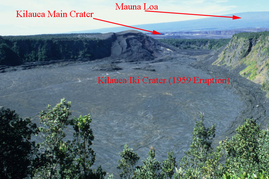
Annotated overview of Kilauea summit region.

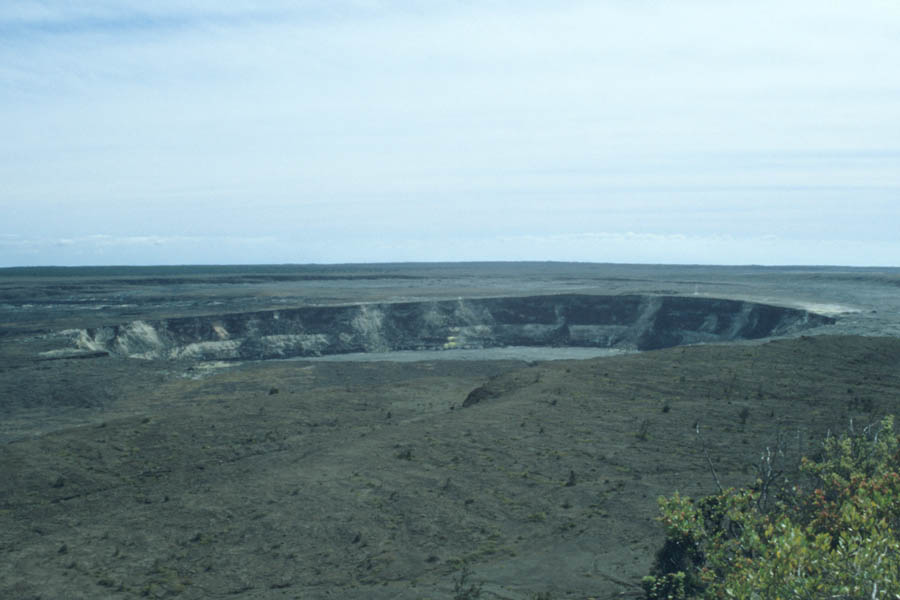
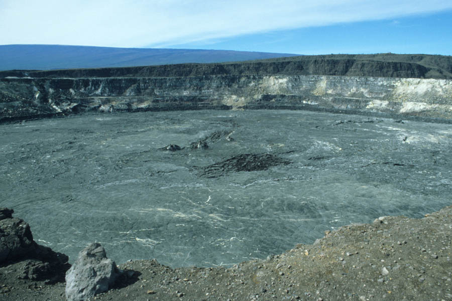
Halema'uma'u crater (1040m) in Kilaueas summit caldera. Site of lava lake until 1924.


From 1823, when records began, until 1924, a large lava lake persisted in the Halemaumau crater . The lake had the following morphology. A semi-solid plug of lava ("epimagma") rested on top of the magma in the pipe-like main conduit. The plug had holes and fissures in it, through which more liquid lava ("pyromagma") could reach the surface. This formed fluctuating lakes of molten lava of varying depths and shapes on top of the plug. Parts of the epimagma protruded, giving the false impression of small islands floating in the lake. Small lava fountains could sometimes be observed much like at Erta Ale lava lake in present years. The continuous circulation of liquid magma in and out of the lake due to convective forces in the conduit and tidal fluctuations is what defined it as a true lava like as opposed to a transient pool of lava.

The level of the lake (including the plug) could rise and fall rapidly, sometimes as much as 100m in a day. In 1924, the level dropped to about 200m below the rim and remained there during March and April. From April 29 to May 6, subsidence of the lake continued, leaving an over 200m deep pit. Between May 10 and May 28, Halemaumau entered into a phase of violent phreatomagmatic activity. The reduced height of the lake in the conduit is thought to have reduced the pressure acting outwards on the walls thereof, allowing entry of groundwater at an approximate depth of 500m. The groundwater was rapidly turned into highly pressurized pockets of steam by the magma in the conduit. Discharges of this pressure propelled hot but solidified material explosively out of the crater. Huge ballistic blocks weighing up to 10 tonnes were thrown to a kilometer from the crater and caused 1 fatality. Ash clouds rose rapidly up to 2km and then by gently convection to heights of over 7km. The eruption gradually increased in intensity with the most violent explosions being recorded on 18 May, before activity gradually sank again. The explosions widened the crater from a diameter of 450m to 1000m. No proper convecting lava lake has been able to establish itself in the crater since then although small amount of material have erupted on the crater floor. However, lava small lakes have been periodically observed in the Pu'u O'o crater in recent times.


Kilauea Summit Crater Kilauea Summit Crater

Halema'uma'u crater (1040m) in Kilaueas summit caldera.

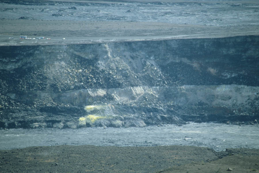
Halema'uma'u crater (1040m). Tourist vehicles at top left provide scale.


In 1959, a summit eruption at Kilauea Iki crater took place from November 14 to December 20. The eruption was characterized by periodic episodes of lava fountaining reaching heights of up to 580m and creating transient lava lakes up to 125m deep, after which massive drainbacks of the lakes into the vent could be observed. These drainbacks presumably kept refilling the magma chamber and allowed a longer persistence of the eruption.


In 1960, a fissure eruption along the E rift zone caused lava fountaining and extensive lava flows which eventually overran hastily erected earth walls and destroyed the town of Kapoho. 2 square km of fresh coastline were added to the island during this eruption.


From May 1969 till July 1974 (with a brief pause in 1971), another eruption of the E rift zone occurred and formed the new Mauna Ulu shield. Multiple periods of lava fountaining up to a maximum height of 540m were observed during the first months of the eruption. Lava flows reached the coast 12km away. The eruption continued with lesser episodes of fountaining and persistent flowing of lavas, mostly through tube systems, to the coastal region and into the sea.


>

Since 1983, Kilauea has again been in almost continuous eruption from the E rift zone. In 1983, a series of up to 470m high lava fountaining episodes, with gaps of up to a week inbetween, were observed along a new fissure. At the main site of this fountaining, the Pu'u O'o cone was rapidly built up. Activity persisted at this site until it shifted 3km further down the rift zone in 1986 where it rapidly formed a broad effusive shield known as Kupaianaha. The lava flow field around Kupaianaha gradually expanded until in November 1986 first flows were reaching the sea. From 1987 till 1989, most of the lava from Kupaianaha continued to enter the sea and build new land. In 1990, the flow directions shifted slightly and over 100 buildings in Kalapana were gradually buried in 15-25m of lava. In February 1992, activity returned to Pu'u O'o, which had been the site of a persistent lava pond since 1990. As the feeder system for Kupaianaha became gradually blocked, the height of the pond in Pu'u O'o began to rise. Activity at Pu'u O'o rapidly built a new shield on the W side of the original cone. Lava flowed from this shield and later again from vents inside Pu'u O'o through a system of tunnels towards the sea. Pu'u O'o eruption since 1983 has been similar in style to that witnessed at Kupaianaha before, being largely effusive and channelling large amounts of lava through mostly closed tube systems towards the sea. Collapses of parts of the original Pu'u O'o cinder cone, episodes of lava overflowing from the crater or breaking out of the tube system occasionally occur. The coastline has been reached over a width of over 15km. A new fissure eruption to the E of Pu'u O'o has been reported in July 2007. Whilst the eruption is not very vigorous, lava flows reached the sea in the Royal Gardens Division area at the beginning of March 2008. (last update March 2008).

For a more detailed chronology of eruptions at Kilauea and for current eruption updates, the reader is referred to the website of the Hawaiian Volcano Observatory (hvo.wr.usgs.gov/Kilauea).


Kilauea Pu'u O'o Crater

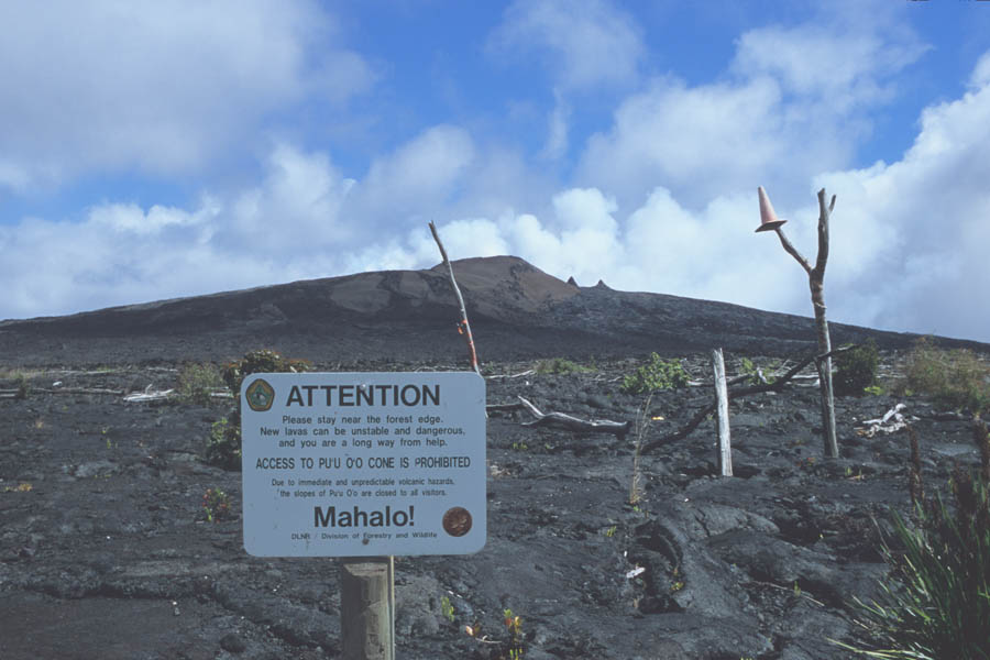
Approaching Pu'u O'o crater, site of ongoing eruption since 1983.

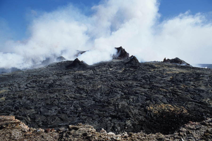
View into Pu'u O'o crater, April 2005.


Crater Floor

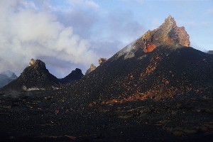
Vents on floor of Pu'u O'o crater.

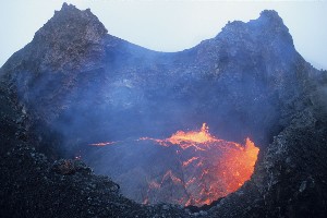
Lava lake in East Pond Vent, Pu'u O'o crater, April 2005.


Lava Fountain in Lake in East Pond Vent, Kilauea Pu'u O'o Crater Peles Tears Kilauea Pu'u O'o Crater

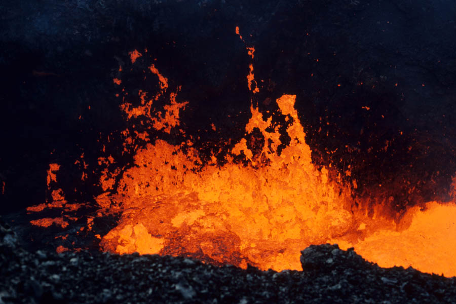
Lava fountain in East Pond Vent lava lake.

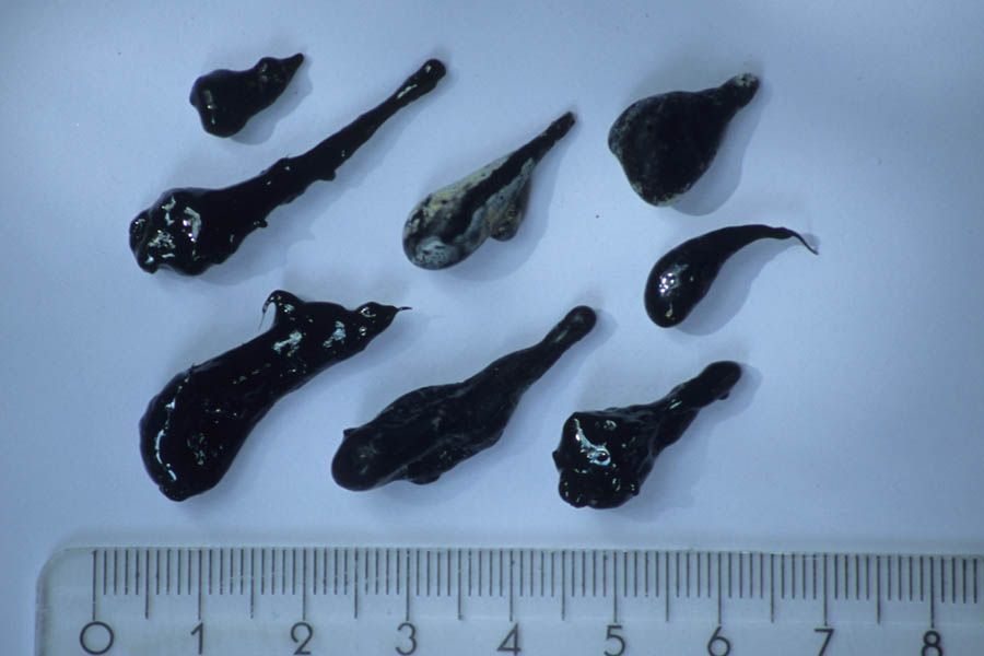
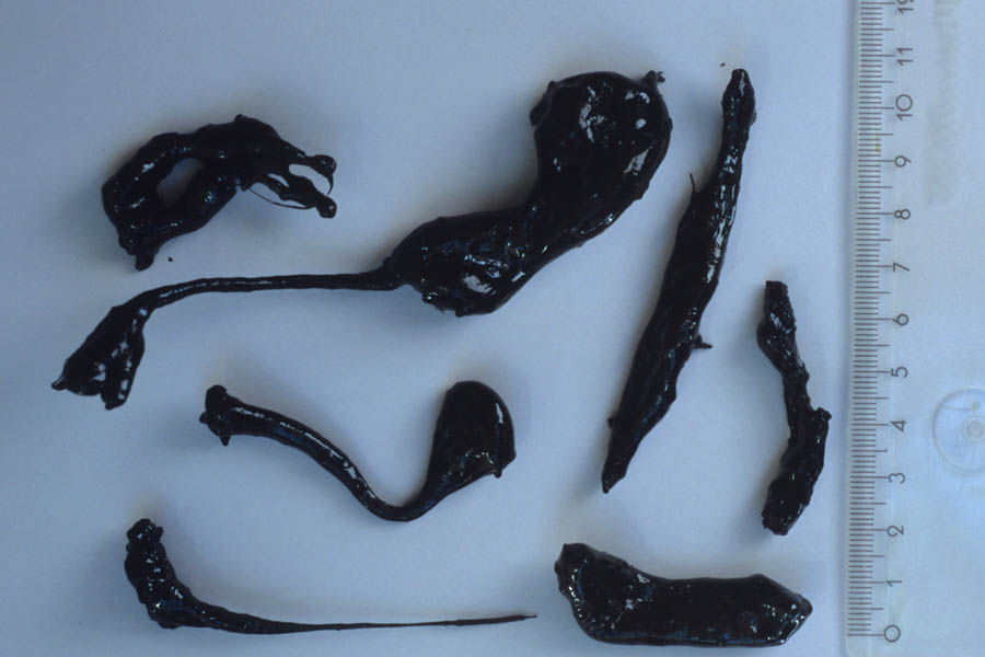
Pele's tears resulting from lava fountaining from East Pond Vent, Pu'u O'o (Scale in cm).


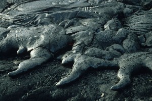
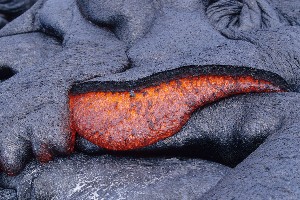
Three solidified lava toes.

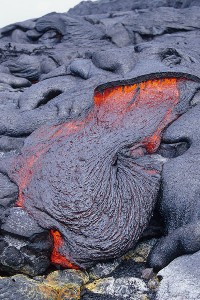
Lava breaking out from under hardened crust and forming small new Pahoehoe flow.

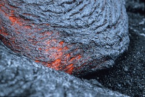
Lava breaking out from under hardened crust.
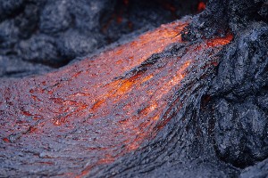

Advancing lava toe.

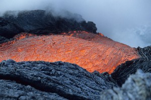
Close-up of lava flow.


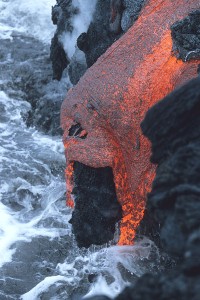
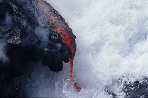
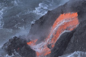
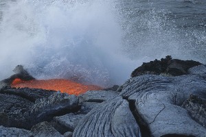
Lava flows entering sea.


Kilauea covers a huge area. Visitors are mostly limited to the few trails and roads in the area. Visiting Pu'u O'o is not allowed although it is possible to fly over it by helicopter. The coastal flow planes are usually accessible and often allow fascinating close encounters with flowing lava, but visitors should take care since it is easy to lose orientation, especially after dark. A headlamp, compass and lots of water are advisable. The coastline is not stable and collapses of lava benches may occur without warning. The flow fields around the shields are uneven and lava tubes may not be able to support your weight.


Further Photos


Peles Tears Kilauea Pu'u O'o Crater Kilauea Iki Destruction

Photovolcanica Full Index